| PID:
|
BBCD02 |
| Designation:
|
867 7832 D TIDAL |
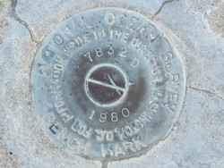
| Stamping:
|
7832 D 1980 |
| Stability:
|
Monument will probably hold position well |
| Setting:
|
Massive retaining walls |
| Description:
|
The disk is set flush in the concrete seawall at the Jekyll Island Marina, 61.0 m south of the south edge of the pier, 10.0 m west of a 30.0 ft antenna mast, 0.24 m east of the west edge of the seawall. |
| Observed:
|
2010-11-01T12:51:00Z |
more obs Original
|
| Source:
|
OPUS - page5 1209.04 |
|
|
|
| Close-up View
|
|
| REF_FRAME:
NAD_83(2011) |
EPOCH:
2010.0000 |
SOURCE:
NAVD88 (Computed using GEOID18) |
UNITS:
m |
SET PROFILE
|
DETAILS
|
|
| LAT:
|
31° 3' 28.04512"
|
± 0.004
m |
| LON:
|
-81° 25' 23.35994"
|
±
0.006
m |
| ELL HT:
|
-26.191 |
±
0.013
m |
| X:
|
815573.522 |
±
0.004
m |
| Y:
|
-5407508.448 |
±
0.014
m |
| Z:
|
3271370.390 |
±
0.003
m |
| ORTHO HT:
|
2.594 |
±
0.051
m |
|
|
UTM
17 |
SPC
1001(GA E) |
| NORTHING:
|
3436083.495m |
117493.944m |
| EASTING:
|
459627.217m |
270959.465m |
| CONVERGENCE:
|
-0.21830991°
|
0.38359520°
|
| POINT SCALE:
|
0.99962010 |
0.99996209 |
| COMBINED FACTOR:
|
0.99962421 |
0.99996620 |
|
|
|
|
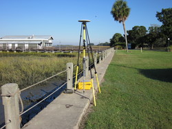
| Horizon View
|
|
|
|
|