| PID:
|
BBCC59 |
| Designation:
|
946 5831 E |
| Stamping:
|
5831 E 2010 |
| Stability:
|
Monument will probably hold position well |
| Setting:
|
A metal rod driven into ground. Describe below. |
| Mark Condition:
|
G |
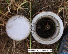
| Description:
|
The bench mark is a stainless steel rod set on the west side of the north bound gravel road leading to the old village, 63.89 m (209.6 ft) NW of bench mark 946 5831 D, 27.37 m (89.8 ft) NW of power pole number Q2 3B, 5.65 m (18.5 ft) west of the centerline of the old village road. The datum point is set 9 cm (0.3 ft) below grade driven 8.5 m (28 ft) to refusal and encased in a 0.16 m (0.6 ft) diameter aluminum NGS Geodetic Control Mark logo cover. |
| Observed:
|
2011-05-29T02:39:00Z |
more obs 2010-11-17
|
more obs Original
|
| Source:
|
OPUS - page5 1209.04 |
|
|
|
| Close-up View
|
|
| REF_FRAME:
NAD_83(2011) |
EPOCH:
2010.0000 |
SOURCE:
NAVD88 (Computed using GEOID12B) |
UNITS:
m |
SET PROFILE
|
DETAILS
|
|
| LAT:
|
59° 45' 1.22575"
|
± 0.003
m |
| LON:
|
-161° 54' 54.85879"
|
±
0.005
m |
| ELL HT:
|
17.412 |
±
0.009
m |
| X:
|
-3062039.894 |
±
0.007
m |
| Y:
|
-999927.595 |
±
0.004
m |
| Z:
|
5486532.435 |
±
0.006
m |
| ORTHO HT:
|
5.450 |
±
0.016
m |
|
|
UTM
4 |
SPC
5007(AK 7) |
| NORTHING:
|
6627208.464m |
640281.194m |
| EASTING:
|
336205.971m |
504764.802m |
| CONVERGENCE:
|
-2.51884957°
|
0.07322021°
|
| POINT SCALE:
|
0.99992881 |
0.99990028 |
| COMBINED FACTOR:
|
0.99992608 |
0.99989755 |
|
|
|
|
| Horizon View
|
|
|
|
|