| PID:
|
BBCC44 |
| Designation:
|
946 9237 A |
| Stamping:
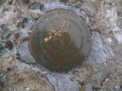
|
9237 A 2005 |
| Stability:
|
May hold, commonly subject to ground movement |
| Setting:
|
Object surrounded by mass of concrete |
| Description:
|
From Nome, AK via sea proceed WSW from Nome Harbor for 6nm then west for 21nm then NW 50nm to a point abeam of King Island, then north for 22nm, then east 15nm, then ESE 10.1nm to Pt. Spencer Light. Then travel over land south along the eastern shore of the spit 0.9mi. The mark is along the shoreline of the spit. It is set in the northern corner of a 1.5m x 1.5m tilted concrete block. The concrete block is 250m north of the remains of a 10m tall tower, 25m west of MHW and 0.6 m above ground. |
| Observed:
|
2010-07-18T21:44:00Z |
more obs Original
|
| Source:
|
OPUS - page5 1209.04 |
|
|
|
| Close-up View
|
|