| PID:
|
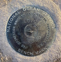
BBCC02 |
| Designation:
|
4070 E |
| Stamping:
|
4070 E 2005 |
| Stability:
|
|
| Setting:
|
Pavement (street, sidewalk, curb, etc.) |
| Mark Condition:
|
G |
| Description:
|
The bench mark is a disk set flush on the seawall in the Havre De Grace Marina, 39.01 m (128.0 ft) from the SE corner of the western most steps in the park, 32.30 m (106.0 ft) from the western edge of the electrical panel in the middle of the park, and 2.29 m (7.5 ft) from electrical pole 239781. |
| Observed:
|
2021-11-16T15:56:00Z |
more obs 2021-12-08
|
| Source:
|
OPUS - page5 2008.25 |
|
|
|
| Close-up View
|
|
| REF_FRAME:
NAD_83(2011) |
EPOCH:
2010.0000 |
SOURCE:
NAVD88 (Computed using GEOID18) |
UNITS:
m |
SET PROFILE
|
DETAILS
|
|
| LAT:
|
39° 32' 16.29395"
|
± 0.006
m |
| LON:
|
-76° 5' 25.08950"
|
±
0.014
m |
| ELL HT:
|
-31.698 |
±
0.011
m |
| X:
|
1184054.053 |
±
0.014
m |
| Y:
|
-4781070.211 |
±
0.007
m |
| Z:
|
4038525.872 |
±
0.011
m |
| ORTHO HT:
|
1.476 |
±
0.051
m |
|
|
UTM
18 |
SPC
1900(MD) |
| NORTHING:
|
4377033.717m |
208107.979m |
| EASTING:
|
406306.648m |
478203.713m |
| CONVERGENCE:
|
-0.69412500°
|
0.57095833°
|
| POINT SCALE:
|
0.99970808 |
1.00001655 |
| COMBINED FACTOR:
|
0.99971305 |
1.00002152 |
|
|
|
|
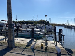
| Horizon View
|
|
|
|
|