| PID:
|
BBCB25 |
| Designation:
|
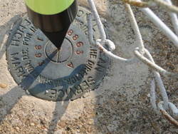
863 8863 A |
| Stamping:
|
8863 A 1993 |
| Stability:
|
May hold, commonly subject to ground movement |
| Setting:
|
Retaining wall or concrete ledge |
| Description:
|
THE BENCH MARK IS SET IN THE CONCRETE BULKHEAD AT THE RIP-RAP ON THE EAST SIDE OF THE TUNNEL ENTRANCE, 35.48 M (116.40 FT) SE OF THE NE CORNER OF THE AIR EXCHANGE BUILDING, 25.69 M (84.28 FT) ENE OF THE SE CORNER OF THE AIR EXCHANGE BUILDING, AND 0.61 M (2.00 FT) WEST OF THE EAST FACE OF THE CONCRETE BULKHEAD. HAND HELD GPS- LATITUDE 36 57'55.2 LONGITUDE 076 06'46.4 |
| Observed:
|
2010-08-27T12:07:00Z |
more obs Original
|
| Source:
|
OPUS - page5 1209.04 |
|
|
|
| Close-up View
|
|