| PID:
|
BBCB15 |
| Designation:
|
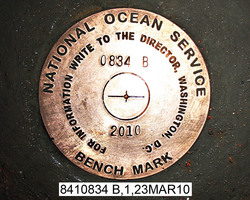
8410834 B |
| Stamping:
|
0834 B 2010 |
| Stability:
|
Monument will probably hold position well |
| Setting:
|
In rock outcrop or ledge |
| Description:
|
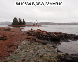
The station is a disk set flush in the top of exposed bedrock on the beach that forms the southern side of the base of Pettegrove Point, 58.13 m (190.7 ft) SE of bench mark 8410834 C, 52.90 m (173.5 ft) NE of the center of the end of a small ravine cut into the embankment above the southern end of the beach, 18.75 m (61.5 ft) SE of the southern most corner of the beach shack on the point, and 12.50 m (41.0 ft) SE of the vegetation line along the top of the beach. |
| Observed:
|
2010-03-23T16:31:00Z |
more obs Latest
|
| Source:
|
OPUS - page5 0909.08 |
|
|
|
| Close-up View
|
|
| REF_FRAME:
NAD_83(CORS96) |
EPOCH:
2002.0000 |
SOURCE:
NAVD88 (Computed using GEOID09) |
UNITS:
m |
SET PROFILE
|
DETAILS
|
|
| LAT:
|
45° 7' 38.59797"
|
± 0.008
m |
| LON:
|
-67° 8' 42.80523"
|
±
0.014
m |
| ELL HT:
|
-19.437 |
±
0.048
m |
| X:
|
1750719.841 |
±
0.019
m |
| Y:
|
-4153677.481 |
±
0.034
m |
| Z:
|
4497334.043 |
±
0.033
m |
| ORTHO HT:
|
3.524 |
±
0.048
m |
|
|
UTM
19 |
SPC
1801(ME E ) |
| NORTHING:
|
4998775.191m |
163192.148m |
| EASTING:
|
645860.380m |
406572.173m |
| CONVERGENCE:
|
1.31466853°
|
0.96018903°
|
| POINT SCALE:
|
0.99986160 |
1.00003961 |
| COMBINED FACTOR:
|
0.99986465 |
1.00004266 |
|
|
|
|
| Horizon View
|
|
|
|
|