| PID:
|
BBBZ40 |
| Designation:
|
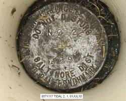
857 1117 TIDAL 2 |
| Stamping:
|
NO 2 1997 |
| Stability:
|
|
| Setting:
|
A metal rod driven into ground. Describe below. |
| Description:
|
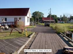
The station is a USACE disk crimped to an aluminum rod driven 12.8 m (42.0 ft) and encased in a 4-inch PVC pipe with a concrete kickblock set 5.81 m (19.1 ft) NW of the W corner of a refreshment stand, 5.24 m (17.2 ft) W of the N corner of a refreshment stand, 3.45 m (11.3 ft) NE of the end of the wooden dock, 0.90 m (3.0 ft) SW of the end of the wooden boardwalk, 0.55 m (1.8 ft) SE of a orange carsonite witness post, and set 0.21 m (0.7 ft) below grade. |
| Observed:
|
2010-07-01T02:10:00Z |
more obs Latest
|
| Source:
|
OPUS - page5 0909.08 |
|
|
|
| Close-up View
|
|
| REF_FRAME:
NAD_83(CORS96) |
EPOCH:
2002.0000 |
SOURCE:
NAVD88 (Computed using GEOID09) |
UNITS:
m |
SET PROFILE
|
DETAILS
|
|
| LAT:
|
37° 59' 45.81671"
|
± 0.005
m |
| LON:
|
-76° 1' 58.89598"
|
±
0.013
m |
| ELL HT:
|
-35.345 |
±
0.025
m |
| X:
|
1214698.249 |
±
0.014
m |
| Y:
|
-4883879.852 |
±
0.018
m |
| Z:
|
3905077.600 |
±
0.015
m |
| ORTHO HT:
|
0.565 |
±
0.025
m |
|
|
UTM
18 |
SPC
1900(MD ) |
| NORTHING:
|
4205881.288m |
37014.576m |
| EASTING:
|
409296.965m |
484940.274m |
| CONVERGENCE:
|
-0.63598208°
|
0.60690547°
|
| POINT SCALE:
|
0.99970133 |
1.00006676 |
| COMBINED FACTOR:
|
0.99970687 |
1.00007231 |
|
|
|
|
| Horizon View
|
|
|
|
|