| PID:
|
BBBZ39 |
| Designation:
|
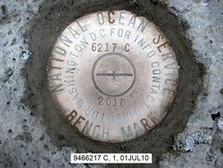
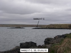
946 6217 C |
| Stamping:
|
6217 C 2010 |
| Stability:
|
Most reliable; expected to hold position well |
| Setting:
|
In rock outcrop or ledge |
| Description:
|
The mark is a disk set in a rock outcrop, 62.3 m (204.4 ft) north of a large boulder near the approximate high waterline at the point projecting into the river channel, 18.1 m (59.4 ft, slope distance) east of a 4 m (13.1 ft) high grassy slope above the rock point, and 7.46 m (24.5 ft) SSW of seaward edge of rocks near the approximate high water line. |
| Observed:
|
2010-07-01T00:34:00Z |
more obs Original
|
| Source:
|
OPUS - page5 1209.04 |
|
|
|
| Close-up View
|
|
| REF_FRAME:
NAD_83(2011) |
EPOCH:
2010.0000 |
SOURCE:
NAVD88 (Computed using GEOID12B) |
UNITS:
m |
SET PROFILE
|
DETAILS
|
|
| LAT:
|
60° 23' 0.82857"
|
± 0.003
m |
| LON:
|
-166° 11' 14.36021"
|
±
0.000
m |
| ELL HT:
|
12.822 |
±
0.002
m |
| X:
|
-3068646.734 |
±
0.003
m |
| Y:
|
-754451.927 |
±
0.001
m |
| Z:
|
5521731.708 |
±
0.001
m |
| ORTHO HT:
|
3.034 |
±
0.007
m |
|
|
UTM
3 |
SPC
5008(AK 8) |
| NORTHING:
|
6694718.663m |
710835.316m |
| EASTING:
|
434544.417m |
489669.690m |
| CONVERGENCE:
|
-1.03223868°
|
-0.16284937°
|
| POINT SCALE:
|
0.99965250 |
0.99990131 |
| COMBINED FACTOR:
|
0.99965049 |
0.99989930 |
|
|
|
|
| Horizon View
|
|
|
|
|