| PID:
|
BBBV43 |
| Designation:
|
841 4249 C |
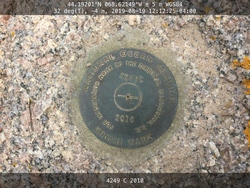
| Stamping:
|
4249 C 2010 |
| Stability:
|
Monument will probably hold position well |
| Setting:
|
In rock outcrop or ledge |
| Mark Condition:
|
G |
| Description:
|
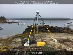
The station is a NOS disk set flush in the bedrock outcrop that forms a point extending NNE into the water separating the eastern and western docks on Liberty Pole Point Rd, 38.70 m (127.0 ft) NNW of the centerline of the road, 31.15 m (102.2 ft) NNW of bench mark 841 4249 B, 25.60 m (84.0 ft) WSW of the eastern-most dock sidewall made of stone blocks, and 18.08 m (59.3 ft) ENE of the face of the western-most dock sidewall made of stone blocks. |
| Observed:
|
2019-08-19T11:52:00Z |
more obs 2019-08-19
|
| Source:
|
OPUS - page5 1603.24 |
|
|
|
| Close-up View
|
|
| REF_FRAME:
NAD_83(2011) |
EPOCH:
2010.0000 |
SOURCE:
NAVD88 (Computed using GEOID18) |
UNITS:
m |
SET PROFILE
|
DETAILS
|
|
| LAT:
|
44° 11' 31.46276"
|
± 0.006
m |
| LON:
|
-68° 37' 17.39845"
|
±
0.016
m |
| ELL HT:
|
-22.291 |
±
0.031
m |
| X:
|
1669757.540 |
±
0.023
m |
| Y:
|
-4265429.744 |
±
0.013
m |
| Z:
|
4423403.361 |
±
0.024
m |
| ORTHO HT:
|
2.479 |
±
0.071
m |
|
|
UTM
19 |
SPC
1801(ME E) |
| NORTHING:
|
4893275.969m |
58379.691m |
| EASTING:
|
530247.874m |
290287.446m |
| CONVERGENCE:
|
0.26384167°
|
-0.08469444°
|
| POINT SCALE:
|
0.99961125 |
0.99990116 |
| COMBINED FACTOR:
|
0.99961474 |
0.99990465 |
|
|
|
|
| Horizon View
|
|
|
|
|