| PID:
|
BBBV39 |
| Designation:
|
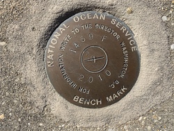
873 1439 F |
| Stamping:
|
1439 F 2010 |
| Stability:
|
May hold, commonly subject to ground movement |
| Setting:
|
Retaining wall or concrete ledge |
| Mark Condition:
|
G |
| Description:
|
The bench mark is a disk set flush in the concrete cap at the north end of Homeport Marina, 32.7 m (107.3 ft) west of the center of the gang way ramp leading to floating dock C, 21.2 m (69.6 ft) east of the center of the gangway ramp leading to floating dock B, and 2.6 m (8.5 ft) south of a concrete block retaining wall. |
| Observed:
|
2023-02-18T15:15:00Z |
more obs 2023-03-21
|
| Source:
|
OPUS - page5 2008.25 |
|
|
|
| Close-up View
|
|