| PID:
|
BBBV11 |
| Designation:
|
8446121 C |
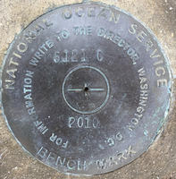
| Stamping:
|
6121 C 2010 |
| Stability:
|
|
| Setting:
|
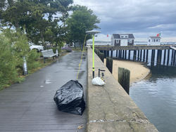
Retaining wall or concrete ledge |
| Mark Condition:
|
G |
| Description:
|
The bench mark is a NOS survey disk set flush in the top of the sea wall forming the SE edge of the Macmillan Warf parking lot area, 35.78 m (117.4 ft) NE of center of ramp down to public floating dock, 28.89 m (94.8 ft) SW of the eastern most corner of sea wall at the entrance of MacMillan Warf, 4.98 m (16.3 ft) SE of edge of pavement of SE side of parking lot, 0.15 m (0.5 ft) SE of inside edge of sea wall, 0.32 m (1.04 ft) above boardwalk. |
| Observed:
|
2021-06-15T13:01:00Z |
more obs 2021-06-30
|
| Source:
|
OPUS - page5 2008.25 |
|
|
|
| Close-up View
|
|
| REF_FRAME:
NAD_83(2011) |
EPOCH:
2010.0000 |
SOURCE:
NAVD88 (Computed using GEOID18) |
UNITS:
m |
SET PROFILE
|
DETAILS
|
|
| LAT:
|
42° 3' 2.59294"
|
± 0.004
m |
| LON:
|
-70° 11' 4.54261"
|
±
0.006
m |
| ELL HT:
|
-24.142 |
±
0.024
m |
| X:
|
1607904.757 |
±
0.005
m |
| Y:
|
-4462362.467 |
±
0.017
m |
| Z:
|
4249772.645 |
±
0.018
m |
| ORTHO HT:
|
3.492 |
±
0.077
m |
|
|
UTM
19 |
SPC
2001(MA M) |
| NORTHING:
|
4656086.457m |
867542.432m |
| EASTING:
|
401971.860m |
308887.899m |
| CONVERGENCE:
|
-0.79349167°
|
0.88359444°
|
| POINT SCALE:
|
0.99971824 |
0.99996796 |
| COMBINED FACTOR:
|
0.99972203 |
0.99997175 |
|
|
|
|
| Horizon View
|
|
|
|
|