| PID:
|
BBBS76 |
| Designation:
|
872 8853 C |
| Stamping:
|
8853 C 2008 |
| Stability:
|
May hold, commonly subject to ground movement |
| Setting:
|
Footings of small/medium structures |
| Mark Condition:
|
G |
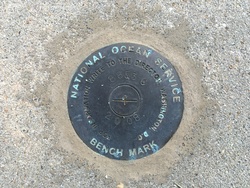
| Description:
|
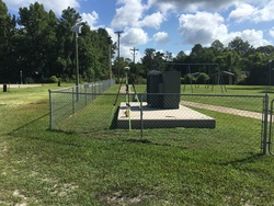
THE BENCH MARK IS A DISC, SET IN A CONCRETE FOUNDATION FOR A TRANSFORMER THAT IS IN THE PLAYGROUND OF THE PARK, SET FLUSH IN THE SOUTHWEST CORNER OF THE CONCRETE FOUNDATION, 43.27 M (142.0 FT) NORTH-NORTHEAST OF THE CENTER OF A GARAGE DOOR FOR THE GULF COUNTY SEARCH AND RESCUE BUILDING, 8.10 M (26.6 FT) NORTHEAST OF THE CENTER OF THE ROAD, 5.80 M (19.0 FT) NORTHWEST OF THE CENTER OF A DOUBLE CHAIN LINK GATE, 2.76 M (9.1 FT) NORTHWEST OF THE SOUTHEAST CORNER OF THE CONCRETE FOUNDATION. |
| Observed:
|
2016-07-08T14:26:00Z |
more obs 2010-03-11
|
| Source:
|
OPUS - page5 1209.04 |
|
|
|
| Close-up View
|
|
| REF_FRAME:
NAD_83(2011) |
EPOCH:
2010.0000 |
SOURCE:
NAVD88 (Computed using GEOID18) |
UNITS:
m |
SET PROFILE
|
DETAILS
|
|
| LAT:
|
29° 52' 50.75746"
|
± 0.002
m |
| LON:
|
-85° 13' 14.87367"
|
±
0.011
m |
| ELL HT:
|
-25.906 |
±
0.015
m |
| X:
|
461140.597 |
±
0.011
m |
| Y:
|
-5515587.220 |
±
0.015
m |
| Z:
|
3158907.474 |
±
0.006
m |
| ORTHO HT:
|
1.449 |
±
0.061
m |
|
|
UTM
16 |
SPC
903(FL N) |
| NORTHING:
|
3306902.703m |
97850.611m |
| EASTING:
|
671818.667m |
530373.060m |
| CONVERGENCE:
|
0.88660995°
|
-0.36221979°
|
| POINT SCALE:
|
0.99996425 |
0.99996086 |
| COMBINED FACTOR:
|
0.99996832 |
0.99996493 |
|
|
|
|
| Horizon View
|
|
|
|
|