| PID:
|
BBBL13 |
| Designation:
|
945 7391 C |
| Stamping:
|
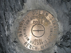
7391 C 2009 |
| Stability:
|
May hold, commonly subject to ground movement |
| Setting:
|
Unspecified rock or boulder |
| Description:
|
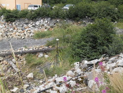
7391 C 2009 is a 3 1/2" domed National Ocean Service brass disk bench mark set flush in smooth, black shale outcrop, on the East side of a gravel launch ramp at the North end of Port Lions small boat harbor, 110m (360.89 ft) NE of bench mark 7391 B, 48.00m (147.48 ft) WSW of bench mark 7391 D, 32.15m( 105.48 ft) East of the NE corner of the wood framed Harbor Masters building,and 7.11m (23.33 ft) SE of the centerline of a gravel boat launch. |
| Observed:
|
2009-07-13T19:14:00Z |
more obs Latest
|
| Source:
|
OPUS - page5 0908.13 |
|
|
|
| Close-up View
|
|
| REF_FRAME:
NAD_83(CORS96) |
EPOCH:
2003.0000 |
SOURCE:
NAVD88 (Computed using GEOID06) |
UNITS:
m |
SET PROFILE
|
DETAILS
|
|
| LAT:
|
57° 52' 24.51083"
|
± 0.009
m |
| LON:
|
-152° 52' 1.66195"
|
±
0.024
m |
| ELL HT:
|
13.866 |
±
0.017
m |
| X:
|
-3025846.129 |
±
0.014
m |
| Y:
|
-1550594.913 |
±
0.020
m |
| Z:
|
5378268.713 |
±
0.019
m |
| ORTHO HT:
|
3.509 |
±
0.121
m |
|
|
UTM
5 |
SPC
5005(AK 5 ) |
| NORTHING:
|
6414631.645m |
431794.423m |
| EASTING:
|
507881.621m |
567217.450m |
| CONVERGENCE:
|
0.11252587°
|
0.95943719°
|
| POINT SCALE:
|
0.99960076 |
0.99995538 |
| COMBINED FACTOR:
|
0.99959859 |
0.99995321 |
|
|
|
|
| Horizon View
|
|
|
|
|