| PID:
|
BBBJ75 |
| Designation:
|
844 8558 TIDAL 9 |
| Stamping:
|
NO 9 1960 |
| Stability:
|
Monument will probably hold position well |
| Setting:
|
Retaining wall or concrete ledge |
| Mark Condition:
|
G |
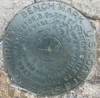
| Description:
|
The bench mark is a NOS survey disk set in an old concrete seawall adjacent to the public piers, 31 m (102 ft) south of the center of the Dock Street, 23 m (75 ft) west of a yard arm shaped flagpole located in front of the JYC yacht club building, 8.9 m (29.46 ft) SSE of S edge of commercial building (Ice Cream Shop) at 11 Dock St. 1.27 m (4.18 ft) E of the E edge of marina parking lot. and 0.3 m (1.0 ft) from the junction of a brick walkway and wooden quay. |
| Observed:
|
2021-06-09T11:10:00Z |
more obs 2021-06-25
|
| Source:
|
OPUS - page5 2008.25 |
|
|
|
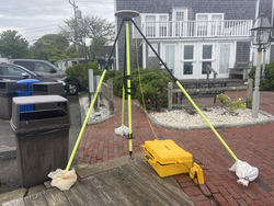
| Close-up View
|
|
| REF_FRAME:
NAD_83(2011) |
EPOCH:
2010.0000 |
SOURCE:
NAVD88 (Computed using GEOID18) |
UNITS:
m |
SET PROFILE
|
DETAILS
|
|
| LAT:
|
41° 23' 20.36508"
|
± 0.005
m |
| LON:
|
-70° 30' 41.12719"
|
±
0.004
m |
| ELL HT:
|
-28.175 |
±
0.004
m |
| X:
|
1598740.943 |
±
0.005
m |
| Y:
|
-4517567.587 |
±
0.001
m |
| Z:
|
4194911.835 |
±
0.006
m |
| ORTHO HT:
|
0.586 |
±
0.067
m |
|
|
UTM
19 |
SPC
2002(MA I) |
| NORTHING:
|
4583042.248m |
43200.670m |
| EASTING:
|
373635.293m |
499044.496m |
| CONVERGENCE:
|
-0.99943611°
|
-0.00755278°
|
| POINT SCALE:
|
0.99979651 |
0.99999849 |
| COMBINED FACTOR:
|
0.99980093 |
1.00000291 |
|
|
|
|
| Horizon View
|
|
|
|
|