| PID:
|
BBBJ42 |
| Designation:
|
844 0273 NO STAMPING 2 |
| Stamping:
|
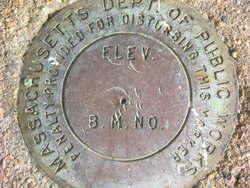
MASSACHUSETTS DPW |
| Stability:
|
Monument will probably hold position well |
| Setting:
|
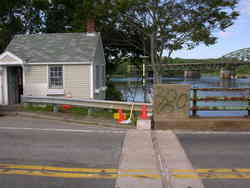
Abutment or pier of large bridges |
| Description:
|
Located in the SW concrete abutment of the main street bridge over the Merrimack River, 4.6 m WSW of the centerline of main street, 4.08 m NNE of the N corner of the bridge tenders house, and 0.21 m NW of the SE edge of the abutment. |
| Observed:
|
2009-06-04T12:04:00Z |
more obs Original
|
| Source:
|
OPUS - page5 1209.04 |
|
|
|
| Close-up View
|
|
| REF_FRAME:
NAD_83(2011) |
EPOCH:
2010.0000 |
SOURCE:
NAVD88 (Computed using GEOID18) |
UNITS:
m |
SET PROFILE
|
DETAILS
|
|
| LAT:
|
42° 50' 5.47929"
|
± 0.006
m |
| LON:
|
-70° 54' 25.93218"
|
±
0.003
m |
| ELL HT:
|
-19.811 |
±
0.008
m |
| X:
|
1532273.284 |
±
0.000
m |
| Y:
|
-4426741.071 |
±
0.009
m |
| Z:
|
4314052.785 |
±
0.005
m |
| ORTHO HT:
|
7.178 |
±
0.052
m |
|
|
UTM
19 |
SPC
2001(MA M ) |
| NORTHING:
|
4744240.159m |
953972.799m |
| EASTING:
|
344129.095m |
248467.322m |
| CONVERGENCE:
|
-1.29694419°
|
0.39819848°
|
| POINT SCALE:
|
0.99989890 |
1.00002580 |
| COMBINED FACTOR:
|
0.99990201 |
1.00002891 |
|
|
|
|
| Horizon View
|
|
|
|
|