| PID:
|
BBBH99 |
| Designation:
|
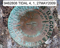
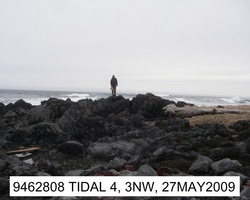
946 2808 TIDAL 4 |
| Stamping:
|
1938 4 |
| Stability:
|
Most reliable; expected to hold position well |
| Setting:
|
In rock outcrop or ledge |
| Description:
|
The station is a disk set in the top of one of many ridges of volcanic rock which extend into the ocean forming a point, 68.5 m (224.7 ft) ESE of the mouth of a creek where it flows from grass to a cobble beach, 12.9 m (42.3 ft) NNW of bench mark 9462808 Tidal 2, 6.6 m (21.6 ft) SE of the grass line, and 1.5 m (4.9 ft) above the grass line.
|
| Observed:
|
2009-04-27T20:36:00Z |
more obs Latest
|
| Source:
|
OPUS - page5 0810.20 |
|
|
|
| Close-up View
|
|
| REF_FRAME:
NAD_83(CORS96) |
EPOCH:
2003.0000 |
SOURCE:
NAVD88 (Computed using GEOID06) |
UNITS:
m |
SET PROFILE
|
DETAILS
|
|
| LAT:
|
54° 23' 39.14616"
|
± 0.012
m |
| LON:
|
-164° 44' 23.20766"
|
±
0.018
m |
| ELL HT:
|
22.637 |
±
0.041
m |
| X:
|
-3590417.590 |
±
0.009
m |
| Y:
|
-979548.260 |
±
0.021
m |
| Z:
|
5162431.158 |
±
0.040
m |
| ORTHO HT:
|
7.504 |
±
0.127
m |
|
|
UTM
3 |
SPC
5010(AK10 ) |
| NORTHING:
|
6027413.991m |
434878.627m |
| EASTING:
|
516895.729m |
1728578.347m |
| CONVERGENCE:
|
0.21157034°
|
8.97352150°
|
| POINT SCALE:
|
0.99960350 |
1.00022101 |
| COMBINED FACTOR:
|
0.99959996 |
1.00021747 |
|
|
|
|
| Horizon View
|
|
|
|
|