| PID:
|
BBBH57 |
| Designation:
|
945 9016 E |
| Stamping:
|
9016 E 2004 |
| Stability:
|
Monument will probably hold position well |
| Setting:
|
Stainless steel rod without sleeve (10FT+ or 3.048M+) |
| Description:
|
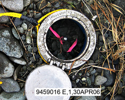
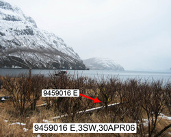
The station is a stainless steel rod driven 6.7 m (22 ft) to refusal and encased in an NGS logo cover which is flush with the ground, 249 m (817 ft) ESE of bench mark 9459016 A, 101 m (331 ft) SE of bench mark 9459016 D, 31 m (102 ft) south of a meandering stream in the grass and alder flats, 30 m (98 ft) SW of the base of a grassy hill below the most prominent rockpeak in the NE corner of the cove, 17.0 m (55.8 ft) ENE of the top edge of the gravel beach, and 0.01m (0.03ft) below grade. |
| Observed:
|
2006-05-01T02:19:00Z |
more obs Original
|
| Source:
|
OPUS - page5 1209.04 |
|
|
|
| Close-up View
|
|
| REF_FRAME:
NAD_83(2011) |
EPOCH:
2010.0000 |
SOURCE:
NAVD88 (Computed using GEOID12B) |
UNITS:
m |
SET PROFILE
|
DETAILS
|
|
| LAT:
|
55° 53' 18.93153"
|
± 0.006
m |
| LON:
|
-158° 49' 7.50542"
|
±
0.011
m |
| ELL HT:
|
18.620 |
±
0.002
m |
| X:
|
-3342925.928 |
±
0.001
m |
| Y:
|
-1295377.019 |
±
0.011
m |
| Z:
|
5257511.292 |
±
0.005
m |
| ORTHO HT:
|
4.172 |
±
0.007
m |
|
|
UTM
4 |
SPC
5006(AK 6) |
| NORTHING:
|
6193695.147m |
210524.752m |
| EASTING:
|
511336.562m |
448774.738m |
| CONVERGENCE:
|
0.15006461°
|
-0.67789884°
|
| POINT SCALE:
|
0.99960158 |
0.99993217 |
| COMBINED FACTOR:
|
0.99959867 |
0.99992925 |
|
|
|
|
| Horizon View
|
|
|
|
|