| PID:
|
BBBH55 |
| Designation:
|
946 9460 A |
| Stamping:
|
9460 A 2003 |
| Stability:
|
Monument will probably hold position well |
| Setting:
|
Stainless steel rod without sleeve (10FT+ or 3.048M+) |
| Description:
|
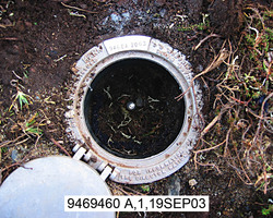
The station is the top of a stainless steel rod driven 3 m (10 ft) to refusal and encased in an NGS Geodetic Control Mark logo cover, 82 m (269 ft) NNE of the western most of a pair of metal culverts beneath the road, 56.37 m (184.9 ft) west of a 0.76 m (2.5 ft) long rebar projecting 0.01 m (0.0 ft) above the ground, 30 m (98 ft) south of the edge of the lagoon, 20.18 m (66.2 ft) south of a 0.76 m (2.5 ft) long rebar projecting 0.02 m (0.1 ft) above the ground, and 0.12 m (0.4 ft) below grade. |
| Observed:
|
2003-09-10T04:00:00Z |
more obs Original
|
| Source:
|
OPUS - page5 1209.04 |
|
|
|
| Close-up View
|
|
| REF_FRAME:
NAD_83(2011) |
EPOCH:
2010.0000 |
SOURCE:
NAVD88 (Computed using GEOID12B) |
UNITS:
m |
SET PROFILE
|
DETAILS
|
|
| LAT:
|
65° 37' 28.98192"
|
± 0.004
m |
| LON:
|
-168° 1' 33.33084"
|
±
0.008
m |
| ELL HT:
|
7.497 |
±
0.024
m |
| X:
|
-2582239.325 |
±
0.006
m |
| Y:
|
-547650.827 |
±
0.009
m |
| Z:
|
5786809.097 |
±
0.023
m |
| ORTHO HT:
|
4.700 |
±
0.041
m |
|
|
UTM
3 |
SPC
5009(AK 9) |
| NORTHING:
|
7281432.744m |
1296374.812m |
| EASTING:
|
360691.206m |
590926.558m |
| CONVERGENCE:
|
-2.75663752°
|
1.79823087°
|
| POINT SCALE:
|
0.99983758 |
1.00000118 |
| COMBINED FACTOR:
|
0.99983641 |
1.00000001 |
|
|
|
|
| Horizon View
|
|
|
|
|