| PID:
|
BBBH54 |
| Designation:
|
949 0424 K |
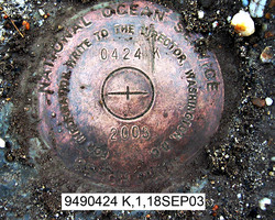
| Stamping:
|
0424 K 2003 |
| Stability:
|
May hold, commonly subject to ground movement |
| Setting:
|
Mat foundation or concrete slab other than pavement |
| Description:
|
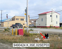
The station is a disk set flush in a concrete slab, 36.6 m (120.1 ft) ESE of bench mark 949 0424 H, 23.5 m (77.1 ft) SSW of the centerline of Turf Street, 9.70 m (31.8 ft) NE of a pedestrian crossing sign, 9.10 m (29.9 ft) WNW of the centerline of 3rd Street, 4.45 m (14.6 ft) WSW of the southern-most of four 0.17 m (0.6 ft) diameter x 1 m (3 ft) high bollards, 3.63 m (11.9 ft) SSW from a telephone pole, and 1.5 m (4.9 ft) ESE of a 0.63 m (2.1 ft) diameter manhole cover.
|
| Observed:
|
2003-09-18T19:40:00Z |
more obs Latest
|
| Source:
|
OPUS - page5 0810.20 |
|
|
|
| Close-up View
|
|
| REF_FRAME:
NAD_83(CORS96) |
EPOCH:
2003.0000 |
SOURCE:
NAVD88 (Computed using GEOID06) |
UNITS:
m |
SET PROFILE
|
DETAILS
|
|
| LAT:
|
66° 54' 6.00530"
|
± 0.010
m |
| LON:
|
-162° 34' 54.63531"
|
±
0.027
m |
| ELL HT:
|
5.050 |
±
0.048
m |
| X:
|
-2394263.711 |
±
0.004
m |
| Y:
|
-751150.097 |
±
0.029
m |
| Z:
|
5844124.540 |
±
0.049
m |
| ORTHO HT:
|
2.972 |
±
0.129
m |
|
|
UTM
3 |
SPC
5006(AK 6 ) |
| NORTHING:
|
7422473.266m |
1444707.205m |
| EASTING:
|
605841.469m |
299501.784m |
| CONVERGENCE:
|
2.22450414°
|
-4.21591619°
|
| POINT SCALE:
|
0.99973711 |
1.00039188 |
| COMBINED FACTOR:
|
0.99973632 |
1.00039109 |
|
|
|
|
| Horizon View
|
|
|
|
|