| PID:
|
BBBH52 |
| Designation:
|
9491253 E |
| Stamping:
|
UNSTAMPED |
| Stability:
|
Monument will probably hold position well |
| Setting:
|
Stainless steel rod without sleeve (10FT+ or 3.048M+) |
| Description:
|
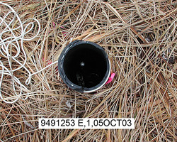
The station is the top of a stainless steel rod driven 13.1 m (43 ft) and encased in a 0.12 m (0.4 ft) diameter black PVC pipe which projects 0.11 m (0.4 ft) above ground, 28.59 m (93.8 ft) ESE of bench mark 949 1253 BLM C4C7, 21 m (69 ft) SSE of the west corner of the new fuel farm fence corner, 13.1 m (43.0 ft) WSW of the SE corner of the new fuel farm fence corner, 8 m (26 ft) east of the cenrterline of an ATV trail, and 0.11 m (0.7 ft) below the top of the PVC pipe. |
| Observed:
|
2003-10-05T00:00:00Z |
more obs Latest
|
| Source:
|
OPUS - page5 0810.20 |
|
|
|
| Close-up View
|
|
| REF_FRAME:
NAD_83(CORS96) |
EPOCH:
2003.0000 |
SOURCE:
NAVD88 (Computed using GEOID06) |
UNITS:
m |
SET PROFILE
|
DETAILS
|
|
| LAT:
|
67° 43' 29.08082"
|
± 0.007
m |
| LON:
|
-164° 31' 58.04296"
|
±
0.002
m |
| ELL HT:
|
4.592 |
±
0.013
m |
| X:
|
-2336823.464 |
±
0.005
m |
| Y:
|
-646618.540 |
±
0.001
m |
| Z:
|
5879528.401 |
±
0.014
m |
| ORTHO HT:
|
4.756 |
±
0.121
m |
|
|
UTM
3 |
SPC
5006(AK 6 ) |
| NORTHING:
|
7512250.862m |
1543694.055m |
| EASTING:
|
519763.270m |
224001.306m |
| CONVERGENCE:
|
0.43234541°
|
-6.04903996°
|
| POINT SCALE:
|
0.99960478 |
1.00083201 |
| COMBINED FACTOR:
|
0.99960406 |
1.00083130 |
|
|
|
|
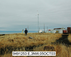
| Horizon View
|
|
|
|
|