| PID:
|
BBBH46 |
| Designation:
|
946 4212 P |
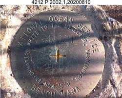
| Stamping:
|
4212 P 2002 |
| Stability:
|
May hold, commonly subject to ground movement |
| Setting:
|
Mat foundation or concrete slab other than pavement |
| Mark Condition:
|
G |
| Description:
|
The bench mark is set flush in a concrete pad on the city fuel dock, 21.25 m (69.7 ft) WSW from the center of the northern-most bollard on the east edge of the dock, 8.70 m (28.5 ft) west of a lightpole on the north edge of the dock, 1.90 m (6.2 ft) east of the center of three holes on top of the metal anchor for ship lines, 1.80 m (5.9 ft) south of the NE corner of the concrete pad, and 0.34 m (1.1 ft) west of the east edge of the concrete pad. |
| Observed:
|
2020-08-09T03:38:00Z |
more obs 2019-08-01
|
| Source:
|
OPUS - page5 2008.25 |
|
|
|
| Close-up View
|
|
| REF_FRAME:
NAD_83(2011) |
EPOCH:
2010.0000 |
SOURCE:
NAVD88 (Computed using GEOID12B) |
UNITS:
m |
SET PROFILE
|
DETAILS
|
|
| LAT:
|
57° 7' 32.43713"
|
± 0.008
m |
| LON:
|
-170° 17' 8.55341"
|
±
0.010
m |
| ELL HT:
|
14.238 |
±
0.011
m |
| X:
|
-3420492.980 |
±
0.004
m |
| Y:
|
-585553.677 |
±
0.011
m |
| Z:
|
5333521.682 |
±
0.013
m |
| ORTHO HT:
|
3.923 |
±
0.353
m |
|
|
UTM
2 |
SPC
5009(AK 9) |
| NORTHING:
|
6331602.235m |
347994.805m |
| EASTING:
|
543244.810m |
482697.155m |
| CONVERGENCE:
|
0.59991667°
|
-0.23995833°
|
| POINT SCALE:
|
0.99962293 |
0.99990367 |
| COMBINED FACTOR:
|
0.99962070 |
0.99990144 |
|
|
|
|
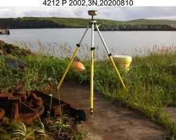
| Horizon View
|
|
|
|
|