| PID:
|
BBBH43 |
| Designation:
|
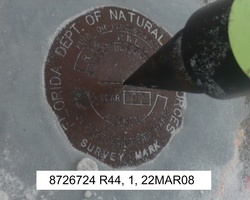
872 6724 R 44 |
| Stamping:
|
R 44 PNLS 97 |
| Stability:
|
Monuments of questionable or unknown reliability |
| Setting:
|
Light structures (other than listed below) |
| Description:
|
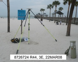
The station is a disk set on the NW corner of a 2 m x 4 m (5 ft x 14 ft) concrete utility housing on the west side of the Clearwater Beach Concession Building, approximately 60 m (197 ft) NE of bench mark 872 6724 N, 11.31 m (37.1 ft) SSW of the corner intersection of the west edge and sidewalk leading to Big 60 Pier, 7.10 m (23.3 ft) NW of the SW corner of the concrete foundation of the deck of the Clearwater Beach Concession Building, and 2.71 m (8.9 ft) west of the west edge of the sidewalk. |
| Observed:
|
2008-03-21T04:00:00Z |
more obs Latest
|
| Source:
|
OPUS - page5 0810.20 |
|
|
|
| Close-up View
|
|
| REF_FRAME:
NAD_83(CORS96) |
EPOCH:
2002.0000 |
SOURCE:
NAVD88 (Computed using GEOID03) |
UNITS:
m |
SET PROFILE
|
DETAILS
|
|
| LAT:
|
27° 58' 37.47062"
|
± 0.010
m |
| LON:
|
-82° 49' 44.00913"
|
±
0.022
m |
| ELL HT:
|
-22.622 |
±
0.027
m |
| X:
|
703669.841 |
±
0.019
m |
| Y:
|
-5592799.130 |
±
0.022
m |
| Z:
|
2974251.287 |
±
0.016
m |
| ORTHO HT:
|
1.980 |
±
0.040
m |
|
|
UTM
17 |
SPC
902(FL W ) |
| NORTHING:
|
3096009.936m |
403945.346m |
| EASTING:
|
320123.514m |
118454.636m |
| CONVERGENCE:
|
-0.85819726°
|
-0.38886958°
|
| POINT SCALE:
|
0.99999936 |
1.00002322 |
| COMBINED FACTOR:
|
1.00000292 |
1.00002677 |
|
|
|
|
| Horizon View
|
|
|
|
|