| PID:
|
BBBH11 |
| Designation:
|
863 2869 C |
| Stamping:
|
2869 C 2007 |
| Stability:
|
Monument will probably hold position well |
| Setting:
|
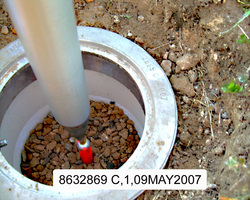
A metal rod driven into ground. Describe below. |
| Description:
|
The station is a 19 m (64 ft) stainless steel rod driven to refusal encased in an aluminum NOS logo cover set 28.1 m (92.2 ft) southwest of the southeast house corner, 27.3 m (89.8 ft) southwest of the southwest house corner, 21.4 m (70.1 ft) West of a flag pole, 18 m (59 ft) North from the top of the bank for Occohannock Creek and 0.12 m (0.40 ft) below grade. |
| Observed:
|
2007-05-09T23:40:00Z |
more obs Latest
|
| Source:
|
OPUS - page5 0810.20 |
|
|
|
| Close-up View
|
|
| REF_FRAME:
NAD_83(CORS96) |
EPOCH:
2002.0000 |
SOURCE:
NAVD88 (Computed using GEOID03) |
UNITS:
m |
SET PROFILE
|
DETAILS
|
|
| LAT:
|
37° 33' 21.68514"
|
± 0.017
m |
| LON:
|
-75° 55' 14.23415"
|
±
0.015
m |
| ELL HT:
|
-35.190 |
±
0.034
m |
| X:
|
1231555.531 |
±
0.009
m |
| Y:
|
-4910507.149 |
±
0.040
m |
| Z:
|
3866473.812 |
±
0.007
m |
| ORTHO HT:
|
1.326 |
±
0.062
m |
|
|
UTM
18 |
SPC
4502(VA S ) |
| NORTHING:
|
4156954.994m |
1138802.118m |
| EASTING:
|
418686.204m |
3727872.685m |
| CONVERGENCE:
|
-0.56118294°
|
1.56548945°
|
| POINT SCALE:
|
0.99968144 |
0.99995080 |
| COMBINED FACTOR:
|
0.99968696 |
0.99995632 |
|
|
|
|
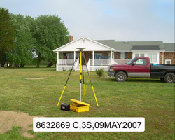
| Horizon View
|
|
|
|
|