| PID:
|
BBBH03 |
| Designation:
|
8635985 A |
| Stamping:
|
5985 A 2007 |
| Stability:
|
Monument will probably hold position well |
| Setting:
|
Stainless steel rod without sleeve (10FT+ or 3.048M+) |
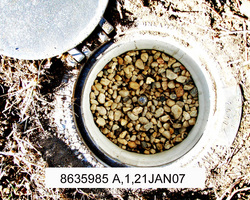
| Description:
|
The station is a stainless steel rod driven 12.9 m (42.3 ft) to refusal and encased in an aluminum NOS logo cover with concrete kickblock, 43.0 m (141.1 ft) NE of the north corner of a block out building, 22.75 m (74.6 ft ) east of the SE corner of John Wares house, 7.15 m (23.5 ft) SSW of the WSW end of the dock platform in the yard, 6.4 m (21.0 ft) west of the top of the riprap on the river bank, and 0.17 m(0.56 ft) below grade. |
| Observed:
|
2007-01-21T23:30:00Z |
more obs Original
|
| Source:
|
OPUS - page5 1209.04 |
|
|
|
| Close-up View
|
|
| REF_FRAME:
NAD_83(2011) |
EPOCH:
2010.0000 |
SOURCE:
NAVD88 (Computed using GEOID18) |
UNITS:
m |
SET PROFILE
|
DETAILS
|
|
| LAT:
|
37° 52' 37.19334"
|
± 0.002
m |
| LON:
|
-76° 47' 22.29685"
|
±
0.003
m |
| ELL HT:
|
-31.572 |
±
0.032
m |
| X:
|
1151967.709 |
±
0.009
m |
| Y:
|
-4907404.338 |
±
0.025
m |
| Z:
|
3894657.152 |
±
0.018
m |
| ORTHO HT:
|
2.557 |
±
0.058
m |
|
|
UTM
18 |
SPC
4502(VA S) |
| NORTHING:
|
4193677.141m |
1172676.177m |
| EASTING:
|
342615.897m |
3650475.135m |
| CONVERGENCE:
|
-1.09893835°
|
1.03812862°
|
| POINT SCALE:
|
0.99990509 |
0.99998486 |
| COMBINED FACTOR:
|
0.99991004 |
0.99998981 |
|
|
|
|
| Horizon View
|
|
|
|
|