| PID:
|
BBBG99 |
| Designation:
|
945 8293 D |
| Stamping:
|
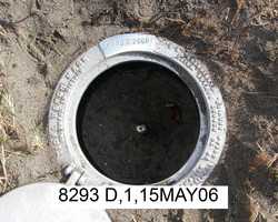
8293 D 2006 |
| Stability:
|
Monument will probably hold position well |
| Setting:
|
Stainless steel rod without sleeve (10FT+ or 3.048M+) |
| Description:
|
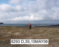
The station is a stainless steel drive rod driven 10.7 m (35 ft) to refusal and encased in a PVC pipe with NOS logo cover set back from a grassy bluff overlooking the sand beach, 116 m (380 ft) SE of benchmark 9458293 C, 106 m (348 ft) NW of benchmark 9458293 E, 71 m (233 ft) NE of the bluff, 65.7 m (215.6 ft) south from the southwestern most of four 2 m (6 ft) high wooden fence posts, 0.79 m (2.6 ft) SSE from a 2.1 m (6.9 ft) tall wooden witness post, and set 0.6 meters (0.2 foot) below grade. |
| Observed:
|
2006-09-03T03:06:00Z |
more obs Original
|
| Source:
|
OPUS - page5 1209.04 |
|
|
|
| Close-up View
|
|
| REF_FRAME:
NAD_83(2011) |
EPOCH:
2010.0000 |
SOURCE:
NAVD88 (Computed using GEOID12B) |
UNITS:
m |
SET PROFILE
|
DETAILS
|
|
| LAT:
|
55° 48' 49.88258"
|
± 0.008
m |
| LON:
|
-155° 44' 24.96742"
|
±
0.005
m |
| ELL HT:
|
24.307 |
±
0.016
m |
| X:
|
-3274816.245 |
±
0.012
m |
| Y:
|
-1475866.273 |
±
0.007
m |
| Z:
|
5252845.030 |
±
0.013
m |
| ORTHO HT:
|
12.187 |
±
0.027
m |
|
|
UTM
5 |
SPC
5005(AK 5) |
| NORTHING:
|
6188760.176m |
203272.091m |
| EASTING:
|
328299.007m |
390915.590m |
| CONVERGENCE:
|
-2.26734460°
|
-1.43971963°
|
| POINT SCALE:
|
0.99996162 |
1.00004591 |
| COMBINED FACTOR:
|
0.99995781 |
1.00004210 |
|
|
|
|
| Horizon View
|
|
|
|
|