| PID:
|
BBBG77 |
| Designation:
|
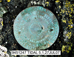
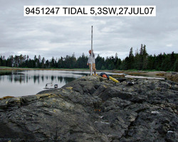
945 1247 TIDAL 5 |
| Stamping:
|
5 1937 |
| Stability:
|
Most reliable; expected to hold position well |
| Setting:
|
In rock outcrop or ledge |
| Description:
|
The station is a disk set on the top of a NNE by SSW oriented rocky islet which drops off rapidly to the east, approximately 91 m (300 ft) NNE of benchmark 9451247 Tidal 4, approximately 60 m (200 ft) south of benchmark 9451247 Tidal 6, 21 m (69 ft) SSW of the MHW line at the NNE end of the islet, 16 m (53 ft) NNE of the SSW end of the islet, and 2 m (7 ft) WNW of the MHW line. |
| Observed:
|
2007-07-27T16:15:00Z |
more obs Latest
|
| Source:
|
OPUS - page5 0810.20 |
|
|
|
| Close-up View
|
|
| REF_FRAME:
NAD_83(CORS96) |
EPOCH:
2003.0000 |
SOURCE:
NAVD88 (Computed using GEOID06) |
UNITS:
m |
SET PROFILE
|
DETAILS
|
|
| LAT:
|
56° 32' 6.95277"
|
± 0.002
m |
| LON:
|
-133° 46' 1.80255"
|
±
0.035
m |
| ELL HT:
|
2.743 |
±
0.025
m |
| X:
|
-2438538.968 |
±
0.020
m |
| Y:
|
-2545803.563 |
±
0.033
m |
| Z:
|
5297541.103 |
±
0.021
m |
| ORTHO HT:
|
4.102 |
±
0.122
m |
|
|
UTM
8 |
SPC
5001(AK 1 ) |
| NORTHING:
|
6266336.224m |
523356.165m |
| EASTING:
|
575820.712m |
812493.964m |
| CONVERGENCE:
|
1.02850882°
|
-0.08311231°
|
| POINT SCALE:
|
0.99967050 |
0.99991588 |
| COMBINED FACTOR:
|
0.99967007 |
0.00000000 |
|
|
|
|
| Horizon View
|
|
|
|
|