| PID:
|
BBBG54 |
| Designation:
|
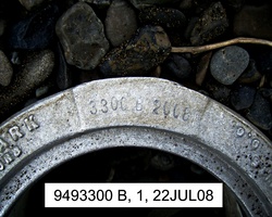
949 3300 B |
| Stamping:
|
3300 B 2008 |
| Stability:
|
Monument will probably hold position well |
| Setting:
|
Stainless steel rod without sleeve (10FT+ or 3.048M+) |
| Description:
|
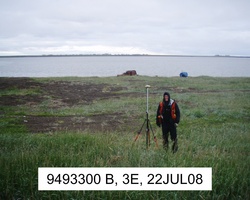
The station is a stainless steel rod driven 3.63 m (11.9 ft) to refusal and encased in an 8-inch PVC pipe with an aluminum National Ocean Service logo cover, 72.93 m (239.3 ft) north of bench mark 9493300 C, 51.43 m (168.7 ft) WNW of bench mark 9493300 A, and 9.21 m (30.2 ft) east of the crest of a small grassy hill, and set 0.03 m (0.1 ft) below grade. |
| Observed:
|
2008-07-23T22:44:00Z |
more obs Original
|
| Source:
|
OPUS - page5 1209.04 |
|
|
|
| Close-up View
|
|
| REF_FRAME:
NAD_83(2011) |
EPOCH:
2010.0000 |
SOURCE:
NAVD88 (Computed using GEOID12B) |
UNITS:
m |
SET PROFILE
|
DETAILS
|
|
| LAT:
|
69° 44' 41.81581"
|
± 0.005
m |
| LON:
|
-163° 3' 54.76604"
|
±
0.003
m |
| ELL HT:
|
3.564 |
±
0.006
m |
| X:
|
-2118610.937 |
±
0.005
m |
| Y:
|
-645088.533 |
±
0.002
m |
| Z:
|
5961252.164 |
±
0.007
m |
| ORTHO HT:
|
4.954 |
±
0.012
m |
|
|
UTM
3 |
SPC
5007(AK 7) |
| NORTHING:
|
7738615.001m |
1754794.658m |
| EASTING:
|
574744.270m |
458832.440m |
| CONVERGENCE:
|
1.81522443°
|
-0.99935474°
|
| POINT SCALE:
|
0.99966834 |
0.99992073 |
| COMBINED FACTOR:
|
0.99966778 |
0.99992017 |
|
|
|
|
| Horizon View
|
|
|
|
|