| PID:
|
BBBG46 |
| Designation:
|
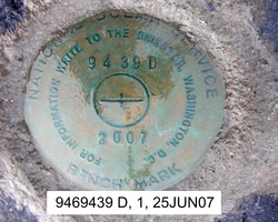
946 9439 D |
| Stamping:
|
9439 D 2007 |
| Stability:
|
Most reliable; expected to hold position well |
| Setting:
|
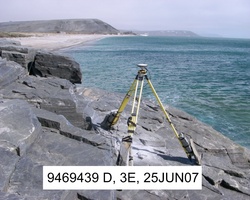
In rock outcrop or ledge |
| Description:
|
The station is a disk set flush in prominent dark gray rock outcrop, 103.2 m (338 ft) ENE of tidal bench mark 9469439 C, 17.79 m (58.4 ft) SW of the east edge of the high rock outcrop, 10.3 m (34 ft) south of the base of the dirt bluff, 8.90 m (29.2 ft) east of the west edge of the high rock outcrop, 6.54 m (21.4 ft) NW of the seaward extent of the rock outcrop, and 2.6 m (9 ft) above the sand beach. |
| Observed:
|
2007-06-25T01:07:00Z |
more obs Latest
|
| Source:
|
OPUS - page5 0810.20 |
|
|
|
| Close-up View
|
|
| REF_FRAME:
NAD_83(CORS96) |
EPOCH:
2003.0000 |
SOURCE:
NAVD88 (Computed using GEOID06) |
UNITS:
m |
SET PROFILE
|
DETAILS
|
|
| LAT:
|
65° 33' 36.72905"
|
± 0.009
m |
| LON:
|
-167° 58' 10.01749"
|
±
0.018
m |
| ELL HT:
|
6.564 |
±
0.022
m |
| X:
|
-2588104.607 |
±
0.019
m |
| Y:
|
-551561.133 |
±
0.018
m |
| Z:
|
5783835.723 |
±
0.017
m |
| ORTHO HT:
|
3.579 |
±
0.122
m |
|
|
UTM
3 |
SPC
5008(AK 8 ) |
| NORTHING:
|
7274124.554m |
1289178.169m |
| EASTING:
|
362950.354m |
409061.293m |
| CONVERGENCE:
|
-2.70379190°
|
-1.79310104°
|
| POINT SCALE:
|
0.99982994 |
1.00000121 |
| COMBINED FACTOR:
|
0.99982891 |
1.00000018 |
|
|
|
|
| Horizon View
|
|
|
|
|