| PID:
|
BBBG44 |
| Designation:
|
863 8445 A |
| Stamping:
|
8445 A 2007 |
| Stability:
|
Monument will probably hold position well |
| Setting:
|
Stainless steel rod without sleeve (10FT+ or 3.048M+) |
| Mark Condition:
|
G |
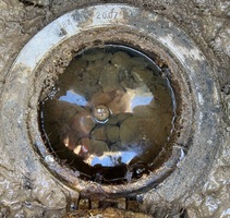
| Description:
|
The benchmark is set in the lawn SE of Colonial Harbor Building. 89.99m(276ft) ENE of BM 863 8445 B, 10.86m(275ft) SE of SE corner of marina building, 10.49m (34.4ft) NE of gas pump, 9.46m(31ft) N of the S edge of the east-west wooden walkway along the waters edge, 8.78m (28.8ft) West of the wooden bulkhead. BM is set 0.06m(.2ft) below grade of lawn, being the top of a stainless steel rod driven 6.09m to refusal, encased in .18(.6ft) diameter NOS logo cover with a subsurface concrete kickblock. |
| Observed:
|
2021-02-03T14:01:00Z |
more obs 2021-02-19
|
| Source:
|
OPUS - page5 2008.25 |
|
|
|
| Close-up View
|
|
| REF_FRAME:
NAD_83(2011) |
EPOCH:
2010.0000 |
SOURCE:
NAVD88 (Computed using GEOID18) |
UNITS:
m |
SET PROFILE
|
DETAILS
|
|
| LAT:
|
37° 24' 5.39276"
|
± 0.005
m |
| LON:
|
-76° 54' 47.32938"
|
±
0.008
m |
| ELL HT:
|
-34.031 |
±
0.008
m |
| X:
|
1148674.062 |
±
0.006
m |
| Y:
|
-4941268.578 |
±
0.011
m |
| Z:
|
3852864.492 |
±
0.002
m |
| ORTHO HT:
|
0.594 |
±
0.053
m |
|
|
UTM
18 |
SPC
4502(VA S) |
| NORTHING:
|
4141130.884m |
1119720.243m |
| EASTING:
|
330666.578m |
3640488.029m |
| CONVERGENCE:
|
-1.16231389°
|
0.96310000°
|
| POINT SCALE:
|
0.99995321 |
0.99994558 |
| COMBINED FACTOR:
|
0.99995855 |
0.99995092 |
|
|
|
|
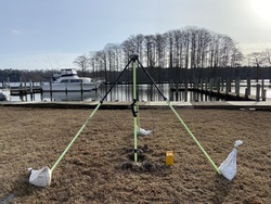
| Horizon View
|
|
|
|
|