| PID:
|
BBBG33 |
| Designation:
|
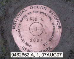
946 2662 A |
| Stamping:
|
2662 A 2007 |
| Stability:
|
May hold, commonly subject to ground movement |
| Setting:
|
In a boulder |
| Description:
|
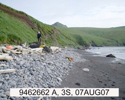
The station is a disk set flush on top of a 3.8 m (12.4 ft) by 3.6 m (11.8 ft) by 1.6 m (5.2 ft) high boulder, 89 m (291.9 ft) SSW from the farthest north waterfall, 40.39 m (132.5ft) north of tidal bench mark 9462662 B, 7.6 m (24.9 ft) ESE from apparent MHW, and 7.0 m (22.9 ft) west from the base of the bluff. |
| Observed:
|
2007-05-30T06:30:00Z |
more obs Original
|
| Source:
|
OPUS - page5 1209.04 |
|
|
|
| Close-up View
|
|
| REF_FRAME:
NAD_83(2011) |
EPOCH:
2010.0000 |
SOURCE:
NAVD88 (Computed using GEOID12B) |
UNITS:
m |
SET PROFILE
|
DETAILS
|
|
| LAT:
|
54° 7' 50.62541"
|
± 0.006
m |
| LON:
|
-166° 5' 57.68674"
|
±
0.004
m |
| ELL HT:
|
20.691 |
±
0.025
m |
| X:
|
-3635755.547 |
±
0.011
m |
| Y:
|
-899801.806 |
±
0.004
m |
| Z:
|
5145300.014 |
±
0.024
m |
| ORTHO HT:
|
4.798 |
±
0.044
m |
|
|
UTM
3 |
SPC
5010(AK10) |
| NORTHING:
|
5998625.321m |
392872.025m |
| EASTING:
|
428164.971m |
1645230.516m |
| CONVERGENCE:
|
-0.89090869°
|
7.89004374°
|
| POINT SCALE:
|
0.99966332 |
1.00010490 |
| COMBINED FACTOR:
|
0.99966008 |
1.00010166 |
|
|
|
|
| Horizon View
|
|
|
|
|