| PID:
|
BBBG32 |
| Designation:
|
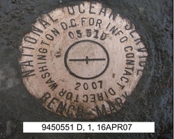
945 0551 D |
| Stamping:
|
0551 D 2007 |
| Stability:
|
Monument will probably hold position well |
| Setting:
|
Object surrounded by mass of concrete |
| Description:
|
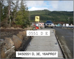
The station is a disk set flush in a concrete anchor on the north side of the boat ramp, 30.0 m (98.4 ft) west of the NW corner of the staging area, 6.85 m (22.5 ft) north of the south edge of the boat ramp, 2.00 m (6.6 ft) north of the south edge of the concrete anchor, 0.75 m (2.5 ft) east of the west edge of the concrete anchor. |
| Observed:
|
2007-04-15T01:23:00Z |
more obs Original
|
| Source:
|
OPUS - page5 1209.04 |
|
|
|
| Close-up View
|
|
| REF_FRAME:
NAD_83(2011) |
EPOCH:
2010.0000 |
SOURCE:
NAVD88 (Computed using GEOID12B) |
UNITS:
m |
SET PROFILE
|
DETAILS
|
|
| LAT:
|
55° 29' 21.89279"
|
± 0.006
m |
| LON:
|
-133° 8' 19.09715"
|
±
0.003
m |
| ELL HT:
|
0.607 |
±
0.012
m |
| X:
|
-2476483.550 |
±
0.010
m |
| Y:
|
-2642853.440 |
±
0.006
m |
| Z:
|
5232444.660 |
±
0.007
m |
| ORTHO HT:
|
4.471 |
±
0.022
m |
|
|
UTM
8 |
SPC
5001(AK 1) |
| NORTHING:
|
6150829.594m |
407042.548m |
| EASTING:
|
617607.501m |
852063.725m |
| CONVERGENCE:
|
1.53397661°
|
0.44709565°
|
| POINT SCALE:
|
0.99976967 |
0.99996739 |
| COMBINED FACTOR:
|
0.99976957 |
0.99996729 |
|
|
|
|
| Horizon View
|
|
|
|
|