| PID:
|
BBBG28 |
| Designation:
|
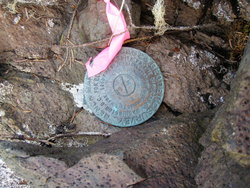
945 1349 TIDAL 1 |
| Stamping:
|
1 |
| Stability:
|
May hold, commonly subject to ground movement |
| Setting:
|
In a boulder |
| Mark Condition:
|
G |
| Description:
|
standard NOS survey disk stamped 1 1929 set flush in the top of a rock about 2 m (6.6 ft) square approximately 1.0 (3.3 ft) meter above apparent mean high water on the SW corner of the south island, 190.0 m (623.4 ft) bearing 066 T (043 M) from the southern point of the island west of the tide gauge site, 59.0 m (193.6 ft) bearing 163 T (140 M) from bench mark 3 1929, 352.0 m (1,154.9 ft) bearing 203 T (180 M) from red daymark R 28 marking The Summit channel. |
| Observed:
|
2009-05-19T17:33:00Z |
more obs 2009-01-16
|
more obs Latest
|
| Source:
|
OPUS - page5 0810.20 |
|
|
|
| Close-up View
|
|