| PID:
|
BBBF92 |
| Designation:
|
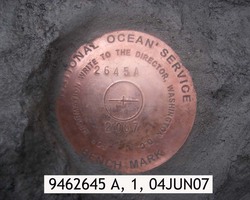
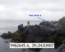
946 2645 A |
| Stamping:
|
2645 A 2007 |
| Stability:
|
Most reliable; expected to hold position well |
| Setting:
|
In rock outcrop or ledge |
| Description:
|
The station is a disk set flush in a large rock outcrop west of Biorka Village, 15 m (50 ft) WNW from a 6 m (20 ft) tall rock point at the beginning of vegetation, 10 m (32 ft) from the south side of the rock point at high tide, 5 m (16 ft) east from the seaward extent of rock point, and 3 m (10 ft) south from the north side of the outcrop. |
| Observed:
|
2007-06-04T00:39:00Z |
more obs Original
|
| Source:
|
OPUS - page5 1209.04 |
|
|
|
| Close-up View
|
|
| REF_FRAME:
NAD_83(2011) |
EPOCH:
2010.0000 |
SOURCE:
NAVD88 (Computed using GEOID12B) |
UNITS:
m |
SET PROFILE
|
DETAILS
|
|
| LAT:
|
53° 49' 46.37980"
|
± 0.008
m |
| LON:
|
-166° 12' 57.69564"
|
±
0.010
m |
| ELL HT:
|
19.819 |
±
0.010
m |
| X:
|
-3663912.516 |
±
0.012
m |
| Y:
|
-898856.618 |
±
0.007
m |
| Z:
|
5125585.747 |
±
0.009
m |
| ORTHO HT:
|
3.454 |
±
0.018
m |
|
|
UTM
3 |
SPC
5010(AK10) |
| NORTHING:
|
5965243.233m |
358616.738m |
| EASTING:
|
419966.565m |
1642222.470m |
| CONVERGENCE:
|
-0.98170715°
|
7.79706749°
|
| POINT SCALE:
|
0.99967860 |
0.99999884 |
| COMBINED FACTOR:
|
0.99967550 |
0.99999574 |
|
|
|
|
| Horizon View
|
|
|
|
|