| PID:
|
BBBF29 |
| Designation:
|
841 0715 B |
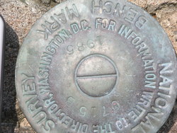
| Stamping:
|
0715 B 1985 |
| Stability:
|
Most reliable; expected to hold position well |
| Setting:
|
In rock outcrop or ledge |
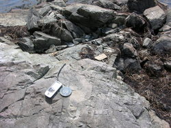
| Description:
|
The station is located 1.0 mi Southeast from Pembroke, on the bank of the Pennamquan River and at the ruins of the R.H. Foster fuel pier, and in the vacinity of the new public boat ramp and parking area. Set in the top of bedrock Southeast of the pier ruins and Northwest of the new floating dock, 27.5 meters Southeast of the pier supporting fuel pipes, 5.8 meters southwest of the tree line, and 1.8 meters northeast of the approximate high water line. |
| Observed:
|
2008-06-20T16:37:00Z |
more obs Original
|
| Source:
|
OPUS - page5 1209.04 |
|
|
|
| Close-up View
|
|
| REF_FRAME:
NAD_83(2011) |
EPOCH:
2010.0000 |
SOURCE:
NAVD88 (Computed using GEOID18) |
UNITS:
m |
SET PROFILE
|
DETAILS
|
|
| LAT:
|
44° 55' 27.40146"
|
± 0.011
m |
| LON:
|
-67° 7' 45.20598"
|
±
0.006
m |
| ELL HT:
|
-18.838 |
±
0.019
m |
| X:
|
1758085.883 |
±
0.004
m |
| Y:
|
-4167901.496 |
±
0.022
m |
| Z:
|
4481380.841 |
±
0.005
m |
| ORTHO HT:
|
3.846 |
±
0.059
m |
|
|
UTM
19 |
SPC
1801(ME E) |
| NORTHING:
|
4976241.120m |
140643.527m |
| EASTING:
|
647639.963m |
408212.845m |
| CONVERGENCE:
|
1.32132684°
|
0.96809677°
|
| POINT SCALE:
|
0.99986804 |
1.00004395 |
| COMBINED FACTOR:
|
0.99987099 |
1.00004690 |
|
|
|
|
| Horizon View
|
|
|
|
|