| PID:
|
BBBF25 |
| Designation:
|
945 5869 H |
| Stamping:
|
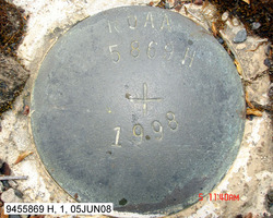
NOAA 5869 H 1998 |
| Stability:
|
Monument will probably hold position well |
| Setting:
|
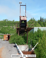
Abutment or pier of large bridges |
| Description:
|
The station is a disk set flush in a concrete abutment NE of the shoreward end of the Tyonek pier, 36.60 m (120.1 ft) SSE of bench mark 9455869 D, 19.17 m (62.9 ft) south of the SW corner of a 9 m (30 ft) square green steel building, 5.0 m (16 ft) ENE of the centerline of the pier, 3.99 m (13.1 ft) SSE of the center of the southern most conveyor support, and 0.82 m (2.7 ft) below the steel deck of the pier. |
| Observed:
|
2008-06-12T19:49:00Z |
more obs Latest
|
| Source:
|
OPUS - page5 0612.06 |
|
|
|
| Close-up View
|
|
| REF_FRAME:
NAD_83(CORS96) |
EPOCH:
2003.0000 |
SOURCE:
NAVD88 (Computed using GEOID06) |
UNITS:
m |
SET PROFILE
|
DETAILS
|
|
| LAT:
|
61° 2' 46.29653"
|
± 0.002
m |
| LON:
|
-151° 10' 3.08006"
|
±
0.013
m |
| ELL HT:
|
13.895 |
±
0.021
m |
| X:
|
-2711878.892 |
±
0.009
m |
| Y:
|
-1492870.465 |
±
0.014
m |
| Z:
|
5557848.419 |
±
0.018
m |
| ORTHO HT:
|
9.034 |
±
0.122
m |
|
|
UTM
5 |
SPC
5004(AK 4 ) |
| NORTHING:
|
6769317.465m |
785208.678m |
| EASTING:
|
598958.171m |
436928.699m |
| CONVERGENCE:
|
1.60356562°
|
-1.02162727°
|
| POINT SCALE:
|
0.99971998 |
0.99994872 |
| COMBINED FACTOR:
|
0.99971781 |
0.99994655 |
|
|
|
|
| Horizon View
|
|
|
|
|