| PID:
|
BBBD25 |
| Designation:
|
945 9881 KCH 1 |
| Stamping:
|
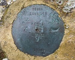
TERRA SURVEYS KCH-1 USACE 1998 |
| Stability:
|
May hold, commonly subject to ground movement |
| Setting:
|
Unspecified rock or boulder |
| Mark Condition:
|
G |
| Description:
|
The station is a disk set in the center of a 1.00 m (3.3 ft) diameter rock, 172 m (564 ft) east of bench mark 945 9881 C, 54 m (177 ft) west of the USCG red #2 channel marker at the entrance to the small boat harbor, 6.5 m (21.3 ft) south of the apparent high water mark on the north side of the rock breakwater, and 6 m (20 ft) north of the apparent high water mark on the south side of the rock breakwater. |
| Observed:
|
2023-06-28T16:15:00Z |
more obs 2020-08-12
|
| Source:
|
OPUS - page5 2008.25 |
|
|
|
| Close-up View
|
|