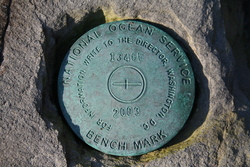
| PID:
|
BBBC61 |
| Designation:
|
945 1346 E |
| Stamping:
|
1346 E 2003 |
| Stability:
|
May hold, commonly subject to ground movement |
| Setting:
|
In a boulder |
| Description:
|
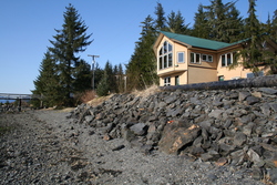
Beginning at the Alaska State Ferry Terminal in Petersburg, Alaska; Proceed south on the Mitkof Highway for 9 miles to Papke's Landing Road; Turn right and proceed west on Papke's Landing Road for 0.5 miles to it's terminus. The Bench Mark is a 3 1/4" brass disk set atop a flat topped boulder in SW corner of a blast rock pile forming parking area/pull-off for a private gravel road paralleling Wrangell Narrows, 158.5' south of Bench Mark 1346 D 2003 |
| Observed:
|
2008-05-04T04:50:00Z |
more obs Original
|
| Source:
|
OPUS - page5 1209.04 |
|
|
|
| Close-up View
|
|
| REF_FRAME:
NAD_83(2011) |
EPOCH:
2010.0000 |
SOURCE:
NAVD88 (Computed using GEOID12B) |
UNITS:
m |
SET PROFILE
|
DETAILS
|
|
| LAT:
|
56° 40' 35.85341"
|
± 0.008
m |
| LON:
|
-132° 56' 1.94856"
|
±
0.005
m |
| ELL HT:
|
2.591 |
±
0.009
m |
| X:
|
-2392305.038 |
±
0.004
m |
| Y:
|
-2571376.449 |
±
0.002
m |
| Z:
|
5306204.717 |
±
0.012
m |
| ORTHO HT:
|
4.330 |
±
0.017
m |
|
|
UTM
8 |
SPC
5001(AK 1) |
| NORTHING:
|
6283297.865m |
539331.744m |
| EASTING:
|
626588.480m |
863590.461m |
| CONVERGENCE:
|
1.72664713°
|
0.61288261°
|
| POINT SCALE:
|
0.99979652 |
0.99990257 |
| COMBINED FACTOR:
|
0.99979611 |
0.99990216 |
|
|
|
|
| Horizon View
|
|
|
|
|