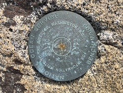
Shared Solution

PID: BBBC59
Designation: 945 1317 C
Stamping: 1317 C 2003
Stability: May hold, commonly subject to ground movement
Setting: In a boulder
Mark Condition: G
Description: BENCHMARK IS SET IN A FLAT TOPPED BOULDER MEASURING APPROXIMATELY 1M (3FT) IN DIAMETER APPROXIMATELY 0.5M (1.5FT) ABOVE THE SURROUNDING TERRAIN AT THE NORTHERN POINT OF ANCHOR POINT. BOULDER IS LOCATED 36M (120FT) NW OF TREELINE ON POINT, 33M NORTH OF FISHING REGULATORY SIGN, 7M (21FT) NNW OF GRASSLINE 8M (25FT), WEST OF 945 1317 D, AND 6.5M (20FT) SW OF 945 1317 TIDAL 3.
Observed: 2022-06-02T17:54:00Z more obs 2018-06-01
Source: OPUS - page5 2008.25
Close-up View
REF_FRAME:   NAD_83(2011) EPOCH:   2010.0000 SOURCE:   NAVD88 (Computed using GEOID12B) UNITS:  m  SET PROFILE   DETAILS
LAT: 56° 38' 18.92994" ±  0.013   m
LON: -132° 55' 38.40028" ±   0.002   m
ELL HT: 2.471 ±   0.031   m
X: -2394421.139 ±   0.019  m
Y: -2574240.194 ±   0.018  m
Z: 5303876.743 ±   0.020  m
ORTHO HT: 4.284 ±  0.355   m
UTM  8 SPC  5001(AK 1)
NORTHING: 6279077.492m 535101.451m
EASTING: 627117.143m 864037.062m
CONVERGENCE: 1.73135833° 0.61827778°
POINT SCALE: 0.99979817 0.99990185
COMBINED FACTOR: 0.99979778 0.99990146
CONTRIBUTED BY
samantha.czwalina
Woolpert Inc.
Horizon View
The numerical values for this position solution have satisfied the quality control criteria of the National Geodetic Survey. The contributor has verified that the information submitted is accurate and complete.