| PID:
|
BBBB51 |
| Designation:
|
946 2620 TIDAL 19 |
| Stamping:
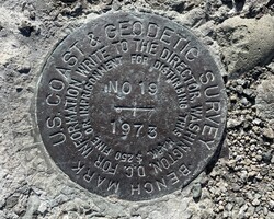
|
NO 19 1975 |
| Stability:
|
May hold, commonly subject to ground movement |
| Setting:
|
Mat foundation or concrete slab other than pavement |
| Mark Condition:
|
G |
| Description:
|
The bench mark is set in the top center of an hexagonal World War II concrete gun-box in front of an apartment building on south side of Bayview Avenue between Third and Fourth Streets, 117 m (383 ft) NW of bench mark 946 2620 TIDAL 16, 6.71 m (22.0 ft) SW of the centerline of Bayview Avenue, and 0.80 m (2.6 ft) above the ground level. |
| Observed:
|
2023-04-26T15:32:00Z |
more obs 2022-06-15
|
| Source:
|
OPUS - page5 2008.25 |
|
|
|
| Close-up View
|
|