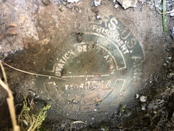
| PID:
|
BBBB50 |
| Designation:
|
945 9450 1293 1 |
| Stamping:
|
1293-1 1984 |
| Stability:
|
May hold, commonly subject to ground movement |
| Setting:
|
Mat foundation or concrete slab other than pavement |
| Mark Condition:
|
G |
| Description:
|
The station is a disk set on the northeast side of the gravel causeway on the north side of the channel entrance to the harbor, 25.0 m (82.0 ft) north of the center of a navigation aid base at the southern end of the northern breakwall, 0.8 m (2.6 ft) north-northeast of a wire rope, 0.45 m (1.5 ft) southwest of the southwest edge of rip-rap on the northeast side of the pier, 0.4 (1.3 ft) north-northwest from 7th post from southern end of breakwall, and 0.3 m (1 ft) below ground. |
| Observed:
|
2020-08-09T00:18:00Z |
more obs 2020-08-08
|
| Source:
|
OPUS - page5 1801.18 |
|
|
|
| Close-up View
|
|