| PID:
|
BBBB43 |
| Designation:
|
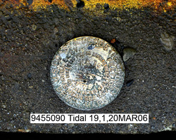
945 5090 TIDAL 19 |
| Stamping:
|
BM 19 1966 |
| Stability:
|
May hold, commonly subject to ground movement |
| Setting:
|
Abutment or pier of large bridges |
| Description:
|
The station is a disk set near the western concrete face of the cruise ship and ferry dock, 15 m (50 ft) west of the southwest corner of the Alaska Railroad Passenger Terminal, 2.44 m (8.0 ft) south of a line tangent to the southern end of the warehouse building, 1.52 m (5.0 ft) west of the west rail, and 0.06 m (0.2 ft) west of a double bollard. |
| Observed:
|
2006-03-21T00:00:00Z |
more obs Original
|
| Source:
|
OPUS - page5 1209.04 |
|
|
|
| Close-up View
|
|
| REF_FRAME:
NAD_83(2011) |
EPOCH:
2010.0000 |
SOURCE:
NAVD88 (Computed using GEOID12B) |
UNITS:
m |
SET PROFILE
|
DETAILS
|
|
| LAT:
|
60° 7' 9.15548"
|
± 0.004
m |
| LON:
|
-149° 25' 42.93177"
|
±
0.008
m |
| ELL HT:
|
19.293 |
±
0.004
m |
| X:
|
-2742793.098 |
±
0.004
m |
| Y:
|
-1620236.417 |
±
0.008
m |
| Z:
|
5507122.673 |
±
0.004
m |
| ORTHO HT:
|
7.257 |
±
0.010
m |
|
|
UTM
6 |
SPC
5004(AK 4) |
| NORTHING:
|
6667167.911m |
681507.557m |
| EASTING:
|
365046.745m |
531766.337m |
| CONVERGENCE:
|
-2.10605897°
|
0.49545117°
|
| POINT SCALE:
|
0.99982319 |
0.99991236 |
| COMBINED FACTOR:
|
0.99982017 |
0.99990934 |
|
|
|
|
| Horizon View
|
|
|
|
|