| PID:
|
AS0424 |
| Designation:
|
872 8626 TIDAL 3 |
| Stamping:
|
NO 3 1973 |
| Stability:
|
May hold commonly subject to ground movement |
| Setting:
|
Set in top of concrete monument |
| Mark Condition:
|
G |
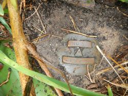
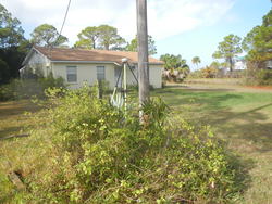
| Description:
|
The bench mark is a disk set flush in the top of a concrete monument, 44 Ft. ESE of the SE corner of a concrete block house, 24 Ft. west of the centerline of West Sawyer Street, 2.5 ft. east of power pole #56X-3456R, 2.5 ft. east of a concrete property corner marker, 2.5 ft. north of a concrete witness post, and 0.5 ft. above street level. |
| Observed:
|
2016-12-06T14:39:00Z |
more obs 2018-08-09
|
| Source:
|
OPUS - page5 1801.18 |
|
|
|
| Close-up View
|
|
| REF_FRAME:
NAD_83(2011) |
EPOCH:
2010.0000 |
SOURCE:
NAVD88 (Computed using GEOID18) |
UNITS:
m |
SET PROFILE
|
DETAILS
|
|
| LAT:
|
29° 39' 7.82093"
|
± 0.006
m |
| LON:
|
-84° 53' 42.72155"
|
±
0.015
m |
| ELL HT:
|
-25.770 |
±
0.014
m |
| X:
|
493596.059 |
±
0.016
m |
| Y:
|
-5525407.864 |
±
0.012
m |
| Z:
|
3136911.755 |
±
0.010
m |
| ORTHO HT:
|
1.352 |
±
0.055
m |
|
|
UTM
16 |
SPC
903(FL N) |
| NORTHING:
|
3282096.130m |
72358.261m |
| EASTING:
|
703730.802m |
561736.822m |
| CONVERGENCE:
|
1.04167500°
|
-0.19859722°
|
| POINT SCALE:
|
1.00011215 |
0.99998857 |
| COMBINED FACTOR:
|
1.00011620 |
0.99999262 |
|
|
|
|
| Horizon View
|
|
|
|
|