| PID:
|
AS0241 |
| Designation:
|
J 45 |
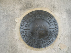
| Stamping:
|
J 45 1934 15.449 |
| Stability:
|
Monuments of questionable or unknown reliability |
| Setting:
|
Pavement (street sidewalk curb etc.) |
| Mark Condition:
|
G |
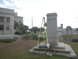
| Description:
|
The bench mark is a disk set in top of the center of the third step from bottom
of base of Marks Monument and on the SE side of the monument, in the SW angle of
the intersection, west and across the street from the courthouse, 64.4
ft S of the centerline of C street, 49.5 ft SW of the center of
U.S. Highway 98, 37.5 Ft SW of a flag pole, and 2.8 ft north of the south edge of the 3RD step of
the monument. |
| Observed:
|
2016-12-05T14:50:00Z |
more obs 2012-04-17
|
| Source:
|
OPUS - page5 1209.04 |
|
|
|
| Close-up View
|
|
| REF_FRAME:
NAD_83(2011) |
EPOCH:
2010.0000 |
SOURCE:
NAVD88 (Computed using GEOID18) |
UNITS:
m |
SET PROFILE
|
DETAILS
|
|
| LAT:
|
29° 43' 32.48139"
|
± 0.013
m |
| LON:
|
-84° 58' 59.72154"
|
±
0.004
m |
| ELL HT:
|
-22.644 |
±
0.016
m |
| X:
|
484750.991 |
±
0.004
m |
| Y:
|
-5522141.918 |
±
0.011
m |
| Z:
|
3143992.649 |
±
0.019
m |
| ORTHO HT:
|
4.507 |
±
0.053
m |
|
|
UTM
16 |
SPC
903(FL N) |
| NORTHING:
|
3290092.829m |
80540.026m |
| EASTING:
|
695063.635m |
553245.897m |
| CONVERGENCE:
|
1.00031496°
|
-0.24284865°
|
| POINT SCALE:
|
1.00006949 |
0.99997794 |
| COMBINED FACTOR:
|
1.00007305 |
0.99998150 |
|
|
|
|
| Horizon View
|
|
|
|
|