| PID:
|
AR1665 |
| Designation:
|
D 290 |
| Stamping:
|
D 290 |
| Stability:
|
May hold commonly subject to ground movement |
| Setting:
|
Retaining wall or concrete ledge |
| Mark Condition:
|
G |
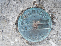
| Description:
|
The bench mark is a disk located along SE of First Street between B Street and C Street, 200 Ft ESE of the fire Station ,89 Ft south of the centerline of First Street, 10 Ft SE of the SW end of the E parking lot, 8 Ft NW of the bulkhead, 0.5 Ft above the parking lot and 0.5 Ft east of the west end of the seawall along the north side of a tidal basin.
**NOTE DATUM PT IS NOT CENTERED, HIGH PT. |
| Observed:
|
2016-12-16T16:29:00Z |
more obs 2014-01-01
|
| Source:
|
OPUS - page5 1209.04 |
|
|
|
| Close-up View
|
|
| REF_FRAME:
NAD_83(2011) |
EPOCH:
2010.0000 |
SOURCE:
NAVD88 (Computed using GEOID18) |
UNITS:
m |
SET PROFILE
|
DETAILS
|
|
| LAT:
|
29° 8' 9.34977"
|
± 0.008
m |
| LON:
|
-83° 1' 52.45410"
|
±
0.006
m |
| ELL HT:
|
-26.008 |
±
0.048
m |
| X:
|
676464.832 |
±
0.002
m |
| Y:
|
-5534306.391 |
±
0.040
m |
| Z:
|
3087056.980 |
±
0.027
m |
| ORTHO HT:
|
1.387 |
±
0.075
m |
|
|
UTM
17 |
SPC
902(FL W) |
| NORTHING:
|
3224751.575m |
532534.982m |
| EASTING:
|
302395.098m |
99652.147m |
| CONVERGENCE:
|
-0.98929646°
|
-0.50213413°
|
| POINT SCALE:
|
1.00008186 |
1.00006539 |
| COMBINED FACTOR:
|
1.00008595 |
1.00006948 |
|
|
|
|
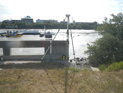
| Horizon View
|
|
|
|
|