| PID:
|
AQ2637 |
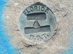
| Designation:
|
872 0954 G |
| Stamping:
|
0954 G |
| Stability:
|
May hold commonly subject to ground movement |
| Setting:
|
Retaining wall or concrete ledge |
| Mark Condition:
|
G |
| Description:
|
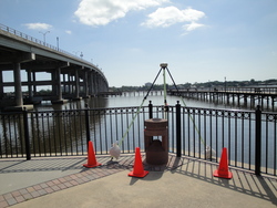
The bench mark is a DD = Survey Disk set in the concrete bulkhead below the SW. end of the State Road 40 bridge over the Halifax River, 106.0 ft. E-NE. of the SW. end of the bulkhead, 83.1 ft. South of the First Bridge Pier, and 62.8 ft. SE. of the SE. side of the bridge. |
| Observed:
|
2016-07-06T14:17:00Z |
more obs 2009-02-04
|
| Source:
|
OPUS - page5 1209.04 |
|
|
|
| Close-up View
|
|
| REF_FRAME:
NAD_83(2011) |
EPOCH:
2010.0000 |
SOURCE:
NAVD88 (Computed using GEOID18) |
UNITS:
m |
SET PROFILE
|
DETAILS
|
|
| LAT:
|
29° 17' 9.61724"
|
± 0.003
m |
| LON:
|
-81° 3' 14.70385"
|
±
0.005
m |
| ELL HT:
|
-26.999 |
±
0.032
m |
| X:
|
865738.617 |
±
0.009
m |
| Y:
|
-5499652.954 |
±
0.026
m |
| Z:
|
3101575.171 |
±
0.017
m |
| ORTHO HT:
|
1.447 |
±
0.063
m |
|
|
UTM
17 |
SPC
901(FL E) |
| NORTHING:
|
3239674.384m |
548729.627m |
| EASTING:
|
494746.749m |
194744.956m |
| CONVERGENCE:
|
-0.02645644°
|
-0.02645644°
|
| POINT SCALE:
|
0.99960034 |
0.99994152 |
| COMBINED FACTOR:
|
0.99960458 |
0.99994576 |
|
|
|
|
| Horizon View
|
|
|
|
|