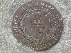
| PID:
|
AQ1543 |
| Designation:
|
NPS RESET |
| Stamping:
|
NPS USDI RESET 1972 |
| Stability:
|
Monuments of questionable or unknown reliability |
| Setting:
|
Pavement (street sidewalk curb etc.) |
| Mark Condition:
|
G |
| Description:
|
The bench mark is a disk cemented flush in a drill hole in the sidewalk West of the seawall, located 174.5 ft. South of a chiseled square designated MARION, 73.8 ft. North of the North curb of the Castillo De San Marcos
National Monument parking lot, 56.2 ft. North of the North one of two manhole covers, 10.0 ft. SW of a set of steps leading to the water, 3.0 ft. WNW of the SW corner of the seawall at the West side of the steps, and 1.0 ft. East of the West edge of the sidewalk. |
| Observed:
|
2016-06-14T12:29:00Z |
more obs 2010-08-13
|
| Source:
|
OPUS - page5 1209.04 |
|
|
|
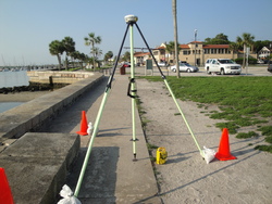
| Close-up View
|
|
| REF_FRAME:
NAD_83(2011) |
EPOCH:
2010.0000 |
SOURCE:
NAVD88 (Computed using GEOID18) |
UNITS:
m |
SET PROFILE
|
DETAILS
|
|
| LAT:
|
29° 53' 47.70168"
|
± 0.006
m |
| LON:
|
-81° 18' 39.92181"
|
±
0.014
m |
| ELL HT:
|
-27.420 |
±
0.018
m |
| X:
|
836011.929 |
±
0.016
m |
| Y:
|
-5470443.417 |
±
0.019
m |
| Z:
|
3160426.917 |
±
0.006
m |
| ORTHO HT:
|
1.212 |
±
0.055
m |
|
|
UTM
17 |
SPC
901(FL E) |
| NORTHING:
|
3307366.732m |
616445.079m |
| EASTING:
|
469965.013m |
169954.761m |
| CONVERGENCE:
|
-0.15505933°
|
-0.15505933°
|
| POINT SCALE:
|
0.99961113 |
0.99995231 |
| COMBINED FACTOR:
|
0.99961543 |
0.99995662 |
|
|
|
|
| Horizon View
|
|
|
|
|