| PID:
|
AQ1070 |
| Designation:
|
J 225 |
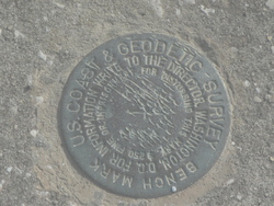
| Stamping:
|
J 225 1964 |
| Stability:
|
May hold commonly subject to ground movement |
| Setting:
|
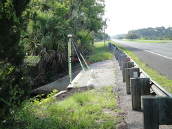
Retaining wall or concrete ledge |
| Mark Condition:
|
G |
| Description:
|
THE MARK IS A DB = BENCH MARK DISK SET IN THE TOP OF AND NEAR THE NORTHWEST END OF THE NORTHEAST HEADWALL OF A LARGE BOX CULVERT WITH ONE DIVIDING PIER UNDER U.S. HIGHWAY 1, 30.0 FT. NORTHEAST OF THE NORTHWEST-BOUND LANES OF THE HIGHWAY, 1.0 FT. SOUTHEAST OF THE NORTHWEST END OF THE HEADWALL, AND ABOUT 2.0 FT. BELOW THE HIGHWAY LEVEL. |
| Observed:
|
2016-07-07T13:30:00Z |
more obs 2002-09-21
|
| Source:
|
OPUS - page5 1209.04 |
|
|
|
| Close-up View
|
|
| REF_FRAME:
NAD_83(2011) |
EPOCH:
2010.0000 |
SOURCE:
NAVD88 (Computed using GEOID18) |
UNITS:
m |
SET PROFILE
|
DETAILS
|
|
| LAT:
|
29° 17' 46.43044"
|
± 0.006
m |
| LON:
|
-81° 4' 46.29110"
|
±
0.022
m |
| ELL HT:
|
-26.717 |
±
0.018
m |
| X:
|
863210.585 |
±
0.024
m |
| Y:
|
-5499489.242 |
±
0.015
m |
| Z:
|
3102563.832 |
±
0.011
m |
| ORTHO HT:
|
1.745 |
±
0.059
m |
|
|
UTM
17 |
SPC
901(FL E) |
| NORTHING:
|
3240808.785m |
549864.415m |
| EASTING:
|
492276.427m |
192273.791m |
| CONVERGENCE:
|
-0.03891375°
|
-0.03891375°
|
| POINT SCALE:
|
0.99960074 |
0.99994191 |
| COMBINED FACTOR:
|
0.99960493 |
0.99994611 |
|
|
|
|
| Horizon View
|
|
|
|
|