| PID:
|
AQ0346 |
| Designation:
|
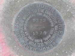
D 322 |
| Stamping:
|
D 322 1970 |
| Stability:
|
May hold commonly subject to ground movement |
| Setting:
|
Set in top of concrete monument |
| Mark Condition:
|
G |
| Description:
|
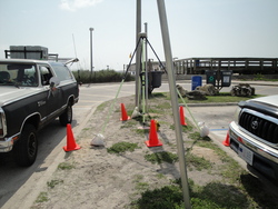
The primary bench mark is a disk set in the top of a round concrete monument projecting 0.3 ft. above the level of the ground. In the NE median island
in the pier parking lot,120.0 ft. NE of the NW corner of the 1-story frame pier office building, 106.0 ft) east of the west end of the median island, 104.0 ft. East of the West end of the median island, 89.0 ft. SSE of the SE corner of a picnic pavilion, 4.9 ft. South of the back of the North curb, and 4.3 ft. North of the back of the South curb. |
| Observed:
|
2016-06-17T13:06:00Z |
more obs 2015-03-07
|
| Source:
|
OPUS - page5 1209.04 |
|
|
|
| Close-up View
|
|
| REF_FRAME:
NAD_83(2011) |
EPOCH:
2010.0000 |
SOURCE:
NAVD88 (Computed using GEOID18) |
UNITS:
m |
SET PROFILE
|
DETAILS
|
|
| LAT:
|
29° 51' 26.34590"
|
± 0.009
m |
| LON:
|
-81° 15' 56.36587"
|
±
0.008
m |
| ELL HT:
|
-25.637 |
±
0.016
m |
| X:
|
840678.889 |
±
0.007
m |
| Y:
|
-5471923.360 |
±
0.011
m |
| Z:
|
3156653.698 |
±
0.015
m |
| ORTHO HT:
|
3.064 |
±
0.056
m |
|
|
UTM
17 |
SPC
901(FL E) |
| NORTHING:
|
3303004.850m |
612081.708m |
| EASTING:
|
474341.359m |
174332.601m |
| CONVERGENCE:
|
-0.13225598°
|
-0.13225598°
|
| POINT SCALE:
|
0.99960812 |
0.99994930 |
| COMBINED FACTOR:
|
0.99961214 |
0.99995333 |
|
|
|
|
| Horizon View
|
|
|
|
|