| PID:
|
AM6922 |
| Designation:
|
853 3615 D TIDAL |
| Stamping:
|
3615 D 1995 |
| Stability:
|
Monument will probably hold position well |
| Setting:
|
Massive structures (other than listed below) |
| Mark Condition:
|
G |
| Description:
|
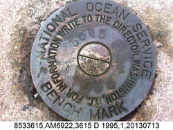
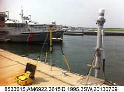
The bench mark is a disk set in a concrete bulkhead on the west end of the US Coast Guard property, 49.29 m (161.7 ft) NW of the USCG flagpole, 31.93 m (104.7 ft) WNW of the SW corner of the USCG building at 601 Bayview Avenue, 22.59 m (74.1 ft) SSW of the northernmost inside corner of the bulkhead at the USCG and Lighthouse Marina property line, and 0.55 m (1.80 ft) NE of the SW edge of the concrete bulkhead. |
| Observed:
|
2013-07-09T14:25:00Z |
more obs 2006-04-21
|
| Source:
|
OPUS - page5 1209.04 |
|
|

|
| Close-up View
|
|
| REF_FRAME:
NAD_83(2011) |
EPOCH:
2010.0000 |
SOURCE:
NAVD88 (Computed using GEOID18) |
UNITS:
m |
SET PROFILE
|
DETAILS
|
|
| LAT:
|
39° 45' 38.67480"
|
± 0.005
m |
| LON:
|
-74° 6' 37.59116"
|
±
0.016
m |
| ELL HT:
|
-32.003 |
±
0.022
m |
| X:
|
1344201.466 |
±
0.021
m |
| Y:
|
-4722122.022 |
±
0.014
m |
| Z:
|
4057579.338 |
±
0.011
m |
| ORTHO HT:
|
1.318 |
±
0.054
m |
|
|
UTM
18 |
SPC
2900(NJ ) |
| NORTHING:
|
4401580.917m |
103024.376m |
| EASTING:
|
576197.316m |
183378.381m |
| CONVERGENCE:
|
0.56897365°
|
0.24915704°
|
| POINT SCALE:
|
0.99967148 |
0.99991371 |
| COMBINED FACTOR:
|
0.99967650 |
0.99991873 |
|
|
|

|
| Horizon View
|
|
|
|
|