| PID:
|
AL7298 |
| Designation:
|
872 7274 A |
| Stamping:
|
7274 A 1976 |
| Stability:
|
Monument will probably hold position well |
| Setting:
|
Copper-clad steel rod without sleeve (10FT+ or 3.048M+) |
| Mark Condition:
|
G |
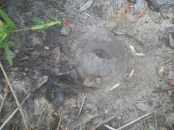
| Description:
|
The bench mark is a disk located 129 ft east of the centerline of the intersection of Battle Creek Road and Standish Drive, 16.5 ft south of the centerline of Standish Drive, 52.2 ft WNW of a white fence corner, 48 ft ESE of a chain link fence corner, and 1.7 ft west of utility pole CR-171-RR-1-28. The bench mark is set at ground level, crimped to the top of a copper-clad steel rod driven 16 ft to refusal, and encased in a PVC pipe and concrete kickblock. |
| Observed:
|
2017-03-10T14:36:00Z |
more obs 2009-01-11
|
| Source:
|
OPUS - page5 1209.04 |
|
|
|
| Close-up View
|
|
| REF_FRAME:
NAD_83(2011) |
EPOCH:
2010.0000 |
SOURCE:
NAVD88 (Computed using GEOID18) |
UNITS:
m |
SET PROFILE
|
DETAILS
|
|
| LAT:
|
28° 45' 44.38795"
|
± 0.007
m |
| LON:
|
-82° 38' 20.71189"
|
±
0.007
m |
| ELL HT:
|
-26.075 |
±
0.029
m |
| X:
|
716895.098 |
±
0.010
m |
| Y:
|
-5549424.336 |
±
0.028
m |
| Z:
|
3050823.112 |
±
0.008
m |
| ORTHO HT:
|
0.900 |
±
0.064
m |
|
|
UTM
17 |
SPC
902(FL W) |
| NORTHING:
|
3182755.849m |
490857.208m |
| EASTING:
|
339977.440m |
137589.153m |
| CONVERGENCE:
|
-0.78885944°
|
-0.30752402°
|
| POINT SCALE:
|
0.99991602 |
0.99998923 |
| COMBINED FACTOR:
|
0.99992012 |
0.99999333 |
|
|
|
|
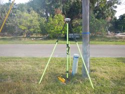
| Horizon View
|
|
|
|
|